T_R_Oglodyte
TUG Lifetime Member
Regulars here know I'm a bit of a geology buff. If that kind of thing doesn't interest you, move on now.
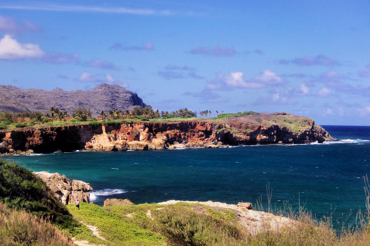
I put up these two photos in a different thread, showing some of the area around the Sunterra Poi'pu resort. The photos look east along the Koloa area shoreline toward Ha'upu, the tall mountain on the left side of the photo. (Ha'upu is also the mountain used in the opening shots of the first Indiana Jones movie, but that shot is from the other side of Ha'upu.
Poipu Point resort, Shipwreck Bay, and Makewehi Cliffs

Rain clouds over Ha'upu

The top photo is taken just south of the Sunterra Po'ipu resort, looking northeasterly across Shipwreck Bay. The white cliff on the far corner of Shipwreck Bay is the start of the Makewehi shoreline cliffs. The second photo was taken along the Makewehi shoreline, beyond the cliff shown in the first. This photo looks across the next bay to the east of Shipwreck Bay. Note the very light colored area on the far shore (that I caught just as it was illuminated by a patch of sunlight) and how those rocks are dissimilar from the darker brown rocks surrounding it on the top and both sides.
****
Now a bit of context. Hawai'ian volcanoes go through a specific death sequence. As the island moves away from the hot spot firing the volcano, the volcano stops erupting and is dormant for hundreds of thousands of years. Finally, as it's last action, the volcano rejuvenates in a series of final eruptions that create various smaller cones and creating a series of lava flows. Diamond Head on O'ahu is a prominent later phase eruptive cone. On Kaua'i Kilohana is a late phase cone, as are all of the cinder cones and small craters in the Po'ipu area.
On Kauai'i those late phase lava flows are called the Koloa formation and they are easy to identify because of their characteristic brown color. The Koloa flows are responsible for all of the level benchlands around the island. For example, on the drive from Kapa'a to Hanalei, as you climb the hill ust past Kealia Beach (and the road swings inland a bit away from the coast), you are climbing onto a Koloa lava flow. You stay on that flow all the way through Princeville. The descent to Hanalei Valley just past Princeville is where you leave the Koloa benchland. From Hanalei to Ke'e Beach, everything you see is old island.
*****
Returning now to the pictures. First note that the Makewehi Cliffs are not volcanic at all - they are entirely lithified sandstone. In the second photo you can see the striations clearly. Also in the second photo you can see how the Makewehi Cliffs are older than the Koloa flows - on the far side of the bay the Koloa flows completely covered the Makewehi sandstones.
For the second part of the story, consider that in the second photo the Makewehi Cliff you see across the bay at some time must have been continuous with the cliffs where the photo was taken. Returning to the first photo, if you are at the Suterra resort and look around the waterfront area on near the north side of the Sunterra property (near the public parking area next to Building 9), you will find the sandstones, again with some Koloa lava overrunning the sandstone. From that point you can look across Shipwreck Bay to the Makewehi Cliff and see how those two points were once connected as well.
Assembling the pieces, at the end of the Koloa eruptions the shoreline in this area was further out from where it is now, and consisted of Makewehi sandstones, overrun in areas by Koloa flows. Shipwreck Bay in the top photo and the smaller bay in the second photo did not exist, because the line of Makewehi dunes marked the shoreline. Wave action subsequently breached the dunes and exposed the area landward of the Makewehi sandstones. Being softer than the Koloa lava, when the dunes were breached, the waves could readily undercut the Koloa lava and widen the Bay opening.
The Makewehi cliffs have survived direct exposure to the waves only in the areas where they stood taller and were thicker, such as where I was when I took the second photo. But they are eroding and will soon (in geologic time) be gone.
This same pattern is repeated over and over along the entire coastline from the Sunterra Resort to the point where the Ha'upu ridge line reaches the ocean.
From the Brennecke's Beach area westward to beyond Spouting Horn, all the exposed rocks on the shoreline are Koloa lavas. If there are any dune rocks in that area, they were completely covered by the Koloa flows.
******
Final note - many of the waterfalls on Kauai'i are created when rivers reach the end of a Koloa flow. Because the Koloa flows resistant erosion better than the underlying, older rocks the river water undercuts the Koloa flow, creating a cliff for the water to flow over.
I put up these two photos in a different thread, showing some of the area around the Sunterra Poi'pu resort. The photos look east along the Koloa area shoreline toward Ha'upu, the tall mountain on the left side of the photo. (Ha'upu is also the mountain used in the opening shots of the first Indiana Jones movie, but that shot is from the other side of Ha'upu.
Poipu Point resort, Shipwreck Bay, and Makewehi Cliffs
Rain clouds over Ha'upu
The top photo is taken just south of the Sunterra Po'ipu resort, looking northeasterly across Shipwreck Bay. The white cliff on the far corner of Shipwreck Bay is the start of the Makewehi shoreline cliffs. The second photo was taken along the Makewehi shoreline, beyond the cliff shown in the first. This photo looks across the next bay to the east of Shipwreck Bay. Note the very light colored area on the far shore (that I caught just as it was illuminated by a patch of sunlight) and how those rocks are dissimilar from the darker brown rocks surrounding it on the top and both sides.
****
Now a bit of context. Hawai'ian volcanoes go through a specific death sequence. As the island moves away from the hot spot firing the volcano, the volcano stops erupting and is dormant for hundreds of thousands of years. Finally, as it's last action, the volcano rejuvenates in a series of final eruptions that create various smaller cones and creating a series of lava flows. Diamond Head on O'ahu is a prominent later phase eruptive cone. On Kaua'i Kilohana is a late phase cone, as are all of the cinder cones and small craters in the Po'ipu area.
On Kauai'i those late phase lava flows are called the Koloa formation and they are easy to identify because of their characteristic brown color. The Koloa flows are responsible for all of the level benchlands around the island. For example, on the drive from Kapa'a to Hanalei, as you climb the hill ust past Kealia Beach (and the road swings inland a bit away from the coast), you are climbing onto a Koloa lava flow. You stay on that flow all the way through Princeville. The descent to Hanalei Valley just past Princeville is where you leave the Koloa benchland. From Hanalei to Ke'e Beach, everything you see is old island.
*****
Returning now to the pictures. First note that the Makewehi Cliffs are not volcanic at all - they are entirely lithified sandstone. In the second photo you can see the striations clearly. Also in the second photo you can see how the Makewehi Cliffs are older than the Koloa flows - on the far side of the bay the Koloa flows completely covered the Makewehi sandstones.
For the second part of the story, consider that in the second photo the Makewehi Cliff you see across the bay at some time must have been continuous with the cliffs where the photo was taken. Returning to the first photo, if you are at the Suterra resort and look around the waterfront area on near the north side of the Sunterra property (near the public parking area next to Building 9), you will find the sandstones, again with some Koloa lava overrunning the sandstone. From that point you can look across Shipwreck Bay to the Makewehi Cliff and see how those two points were once connected as well.
Assembling the pieces, at the end of the Koloa eruptions the shoreline in this area was further out from where it is now, and consisted of Makewehi sandstones, overrun in areas by Koloa flows. Shipwreck Bay in the top photo and the smaller bay in the second photo did not exist, because the line of Makewehi dunes marked the shoreline. Wave action subsequently breached the dunes and exposed the area landward of the Makewehi sandstones. Being softer than the Koloa lava, when the dunes were breached, the waves could readily undercut the Koloa lava and widen the Bay opening.
The Makewehi cliffs have survived direct exposure to the waves only in the areas where they stood taller and were thicker, such as where I was when I took the second photo. But they are eroding and will soon (in geologic time) be gone.
This same pattern is repeated over and over along the entire coastline from the Sunterra Resort to the point where the Ha'upu ridge line reaches the ocean.
From the Brennecke's Beach area westward to beyond Spouting Horn, all the exposed rocks on the shoreline are Koloa lavas. If there are any dune rocks in that area, they were completely covered by the Koloa flows.
******
Final note - many of the waterfalls on Kauai'i are created when rivers reach the end of a Koloa flow. Because the Koloa flows resistant erosion better than the underlying, older rocks the river water undercuts the Koloa flow, creating a cliff for the water to flow over.
Last edited:
")